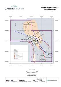
- Initial 5-hole diamond drill program totalling 3,300m will test geophysical and geological targets for epithermal polymetallic Ag-Pb-Zn mineralization in the general vicinity of the artisanal silver mine.
- Additional IP/Res surveys in the NW part of the property have added more than a kilometre of additional strike length to the potential mineralized zone.
The additional geophysical work consisted of six Induced Polarization (IP/Res) lines surveyed by MES Geophysics in the northwest part of the Gonalbert property. The same array of eight fifty-metre and four offset one hundred-meter dipoles was used to obtain chargeability and resistivity data to a depth of about four hundred meters. Figure 3 shows that the resistivity anomaly along the prominent west-northwest fault extends for an additional kilometer of strike length. The corresponding chargeability map, Figure 4, shows an additional centre of chargeability at a depth of one hundred metres. This chargeability anomaly extends west-northwestward from 218900E for about 250m before it turns north along a cross-cutting north-south fault. The Chargeability and Resistivity data add more than a kilometre of strike length to the mineralized structure that is being drill tested in the current program, showing the impressive lateral extent and strength of the mineralizing system at Gonalbert.
Qualified Person
Dr.
About
Cartier Silver is an exploration and development Company focused on discovering and developing its recently acquired silver property assets, including the
For further information please visit Cartier Silver’s website at www.cartiersilvercorp.com
For further information please contact:
| Chief Executive Officer | Vice-President |
| (800) 360-8006 | (800) 360-8006 |
| (416) 360-8006 | (416) 360-8006 |
The CSE has not reviewed nor accepts responsibility for the adequacy or accuracy of this release.
Statements in this release that are not historical facts are “forward-looking statements” and readers are cautioned that any such statements are not guarantees of future performance, and that actual developments or results, may vary materially from those in these “forward-looking statements”.
Figure 1: Geology Plan Map of Gonalbert Property Showing Locations of Planned Drill Holes.
Table 1: Collar Coordinates and Orientation Information, Planned Diamond Drill Holes, Gonalbert Property
| Drillhole Name | Easting | Northing | Elevation | Azimuth | Dip | Target Depth (m) |
| GAL_01 | 219000.00 | 7637460.00 | 3669.45 | 60 | 70 | 700 |
| GAL_02 | 219214.71 | 7637583.95 | 3581.77 | 60 | 70 | 500 |
| GAL_03 | 218742.17 | 7637542.18 | 3596.29 | 60 | 50 | 700 |
| GAL_04 | 219259.91 | 7637494.51 | 3566.45 | 60 | 70 | 500 |
| GAL_05 | 219000.00 | 7637344.43 | 3667.28 | 60 | 70 | 900 |
| Total | 3,300 |
Note: Coordinates are in metres; azimuth and dip are in degrees
Figure 2: Cross Sections of Planned Drill Holes showing Location of Coincident Chargeability and Resistivity Anomalies being Drill-tested.
Figure 3: Resistivity Plan Map at N=4, Elevation 100m Below Surface with Additional Coverage in the NW Part of the Gonalbert Property
Figure 4: Chargeability Plan Map at N=4, Elevation 100m Below Surface with Additional Coverage in the NW Part of the Gonalbert Property
PDF available: http://ml.globenewswire.com/Resource/Download/d9a891e2-d520-4b9e-8a85-4c435c572ec7

![]()
Figure 1
Geology Plan Map of Gonalbert Property Showing Locations of Planned Drill Holes
Figure 2
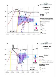
Cross Sections of Planned Drill Holes showing Location of Coincident Chargeability and Resistivity Anomalies being Drill-tested
Figure 3
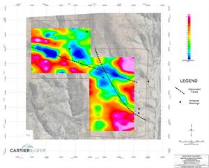
Resistivity Plan Map at N=4, Elevation 100m Below Surface with Additional Coverage in the NW Part of the Gonalbert Property
Figure 4
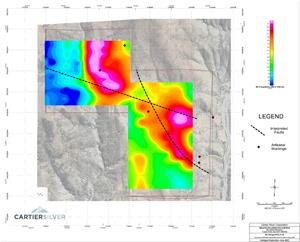
Chargeability Plan Map at N=4, Elevation 100m Below Surface with Additional Coverage in the NW Part of the Gonalbert Property
2023 GlobeNewswire, Inc., source
