(via TheNewswire)

The drill program is designed to test up to five target zones which measure from hundreds of metres (m) to over one kilometre (km) in strike length along a 4 km, east-west trend of gold-silver mineralization identified in 3-dimensional (3D) modelling incorporating data from over 3,000 soil, chip and channel samples, 26 prior diamond drill holes, geological and structural mapping and the potential continuity at depth of surface mineralization as indicated by an Induced Polarization/Magnetometer (IP/Mag) geophysical survey (please refer to the descriptions of target zones in the press release dated
An additional three diamond drill holes have been completed for a total of 569.5 metres bringing the total metres (m) reported to date to 995.5 m in 7 holes. The first four holes tested the TA-2 target in the Carneritos area of the project (refer to press release dated
|
Hole |
Weighted Average Gold |
Weighted Average Silver | Weighted Average Gold Equivalent* | ||||
Location | Number | From | To | Total | Grade | Grade | Grade |
(m) | (m) | (m) | (g/t) | (g/t) | (g/t) | ||
Masuparia | TEN 21-05 | 12.0 | 28.5 | 16.5 | 0.27 | 4.6 | 0.34 |
172.5 | 195.0 | 22.5 | 0.22 | 3.0 | 0.26 | ||
TEN 21-06 | 0.0 | 18.0 | 18.0 | 1.21 | 1.5 | 1.23 | |
(including) | 16.5 | 18.0 | 1.5 | 6.46 | 2.8 | 6.50 | |
27.0 | 49.5 | 22.5 | 0.57 | 0.6 | 0.58 | ||
(including) | 27.0 | 39.0 | 12.0 | 0.83 | 0.5 | 0.84 | |
TEN 21-08 | 60.0 | 73.5 | 13.5 | 0.30 | 6.4 | 0.40 | |
103.5 | 111.0 | 7.5 | 0.22 | 1.3 | 0.24 |
Notes: Gold Equivalentwhere silver grade is converted to gold grade at 75 grams per tonne silver = 1 gram per tonne gold.
Mammoth attempts to drill as near perpendicular as believed to be the orientation of mineralized control features, however lengths shown are core lengths versus perpendicular true length of mineralized intersections.
“It’s important to keep in mind that Tenoriba is a very large, at least 4 to 6 kilometre long mineralized system with gold-silver sampled in thousands of surface samples and as such an excellent candidate for large scale open pit mining. As evidenced in hole 21-06 and numerous other historic drill holes, wecan often intersect tens of metres of higher-grade gold-silver mineralization at shallow depths, accompanied by similar intervals of more modest, yet still potentially economical grades.
“What’s encouraging about the higher-grade intervals at Tenoriba is that the mineralized trend being as large as it is and taking into account that we’re testing target areas that measure hundreds of metres to over a kilometre in length and drilling 60 to greater than 200 metres step-outs from sparse prior drilling, when one considers the that the drill core measures only 6.5 centimetres in diameter, hitting these higher grade intervals within this giant mineralized system at Tenoriba, in these large step-outs, we’re literally encountering needles in a haystack of mineralization at this stage of the drilling. However, as evidenced by these higher-grade intervals we’re able to intersect these ‘needles’ in this ‘haystack’ which bodes well for the potential of the project.”
Drill Hole Description:
As previously discussed, Mammoth intends to initially drill 2 to 4 holes within each target zone then move to another target zone to drill a similar number of holes (please refer to press release dated
Targets TEN 21-05 and 06 were drilled to test the interpreted F3, west-northwest fault as identified in the 3D geophysical interpretation within the generallywest-northwest – east-southeast TA-3(a) mineralized trend/target area. In both holes the F3 fault was intercepted and coincides with highly fractured/grinded core intervals from 113 to 139 and 117 to 124 m core length in hole 21-05 and 21-06, respectively. These intervals were not mineralized. As a result, it can be said that the F3 fault appears to be an un-mineralized, late, normal fault (south block down) and the mineralization intervals encountered in these holes does not appear to be fault controlled, but may be an extension of the general west-northwest - east-southeast TA-3(a) mineralized trend.
The second target; TEN21-08 was drilled to test the north extension of the west-northwest trending Metalito structure which was observed in a small artisanal mine where surface samples assayed up to 1.3 grams/tonne (g/t) gold over 1.8 m and where dickite clay (an alteration clay commonly observed in High Sulphidation precious metal systems), was also observed.The Metalito structure was intercepted from 58 to 76 m and it was within this structure that the reported gold-silver values were encountered.
Drill Hole TEN 21-05
The hole was drilled to a depth of 220.5 m of a planned 200 to 250 m depth at 65 degrees decline/dip, azimuth 20 degrees and was collared approximately 170 m east-southeast of TDH-10 and 175 m southwest of TDH-07. This drill hole was collared to test the interpreted F3, west-northwest fault as identified in the 3D geophysical interpretation within what appears a possiblewest-northwest and east-southeast mineralized trendas identified in target area TA-3(a).
Historic drill hole TDH-10 returned 26.7 m grading 0.66 g/t gold equivalent (Eq) followed by 41.0 m grading 0.92 g/t gold Eq, while TDH-07 returned 47.0 m grading 2.17 g/t gold Eq followed by 11.5 m grading 2.32 g/t gold Eq.
TEN 21 - 05 intercepted from surface to 194 m core length crystal volcanic tuff with traces, to up 5% locally of pyrite in irregular veinlets with minor quartz throughout. From 113 to 139 m core length frequent intervals of broken and grinded core were noted which coincides with the interpretation of the F3 fault. As the fault interval was not mineralized it is interpreted to be a late, normal fault (south block down) and the mineralization interval encountered in this hole does not appear to be fault controlled but rather appears to be an extension of the generally west-northwest and east-southeast mineralized trend. Hole TEN 21 - 06 collared 200 m northwest of TEN 21-05 was drilled to further test this structure and the possible west-northwest and east-southeast mineralized trend as identified in target area TA-3(a).
Drill Hole TEN21-06
The hole was drilled to a depth of 196.5 m of a planned 200 to 250 m depth at 55 degrees decline/dip, azimuth 0 degrees and was collared approximately 75 m southeast of TEN17-15, 65 m west-southwest of collar TDH-11. This drill hole was collared to test the interpreted F3, west-northwest fault as identified in the 3D geophysical interpretation within what appears a possible west-northwest and east-southeast mineralized trend as identified in target area TA-3(a).
Historic drill hole TEN17-15 returned 12 m grading 0.71 g/t gold Eq followed by 13.6 m grading 0.47 g/t gold Eq, and TDH-11 returned 26.7 m grading 0.66 g/t gold Eq followed by 41 m grading 0.92 g/t gold Eq.
TEN 21-06 intercepted from the top to the bottom of the hole crystal volcanic tuff, generally weakly sericitized and or chloritized with less than 1% disseminated fine pyrite. From 117 to 124 m core length frequent intervals of broken and grinded core were noted which coincides with the interpretation of the F3 fault. As the fault interval was not mineralized it is interpreted to be a late, normal fault (south block down) and the mineralization intervals encountered in this hole does not appear to be fault controlled but rather is an extension of the generally west-northwest and east-southeast mineralized trend.
Drill Hole TEN21-08
The hole was drilled to a depth of 152.5 m of a planned 100 m depth at 60 degrees decline/dip, azimuth 250 degrees and was collared approximately 700 m northwest of TEN17-09. This drill hole was originally intended to be collared 400 m further northwest of its drilled location corresponding with both a large IP geophysics feature at this original location and what would be a lengthy lateral extension to theMetalito targeted structure. The hole was unable to be located at its original location due to the steepness of the ground at this location. This hole was instead collared along strike of the Metalito structure below a small mine working where dickite clay alteration (an alteration clay commonly observed in High Sulphidation precious metal systems)was present and numerous surface gold assays existed, the best result 1.3 g/t gold over 1.8 m.
Historic drill hole TEN17-09 intersecting the Metalito structure returned 3 m grading 0.42 g/t gold Eq.
TEN 21-08 intercepted from surface to 58 m core length, non-mineralized lithic volcanic tuff, followed by the Metalito structure from 58 to 76 m. The Metalito structure coincides with mineralized, brecciated volcanic tuff with abundant presence of pyrite veinlets and an approximate 1 m interval with white clay and sulfide veinlets at a 65° angle from the core axis. From 76 meters to the end of the hole there was a repeat of the same non-mineralized lithic volcanic tuff. This drill hole demonstrates lengthy lateralcontinuity of this Metalito mineralized structure, given its 700 m step-out from any prior drilling although with modest, yet potentially economical grade mineralization over a decent 13.5 m interval at a relatively shallow, less than 50 m vertical depth. The original, large IP geophysics feature, along strike with the Metalito structure located in the steep terrain 400 m to the northwest, remains to be tested.
Qualified Person / Quality Controls:
Samples referenced in this press release were prepared and analyzed by ALS laboratories (ALS) in their facilities in
About
To find out more about
Neither the
Forward Looking Information: This news release may contain or refer to forward-looking information. All information other than statements of historical fact that address activities, events or developments that the Company believes, expects or anticipates will or may occur in the future are forward-looking statements; examples include the listing of its shares on a stock exchange and establishing mineral resources. These forward-looking statements are subject to a variety of risks and uncertainties beyond the Company's ability to control or predict that may cause actual events or results to differ materially from those discussed in such forward-looking statements. Any forward-looking statement speaks only as of the date on which it is made and, except as may be required by applicable securities laws, the Company disclaims any intent or obligation to update any forward-looking statement, whether as a result of new information, future events or results or otherwise. Although the Company believes that the assumptions inherent in the forward-looking statements are reasonable, forward-looking statements are not guarantees of future performance and, accordingly, undue reliance should not be placed on these forward-looking statements due to the inherent uncertainty therein.
Figure 1 - Location Map, Tenoriba Property Drilling, 2022 (drill holes TEN 21-05, 06 and 08)
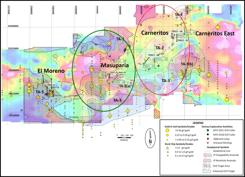
Click Image To View Full Size
Figure 2 - Location Map, Masuparia Area, Tenoriba Property Drilling, 2022 (drill holes TEN 21-05, 06 and 08)
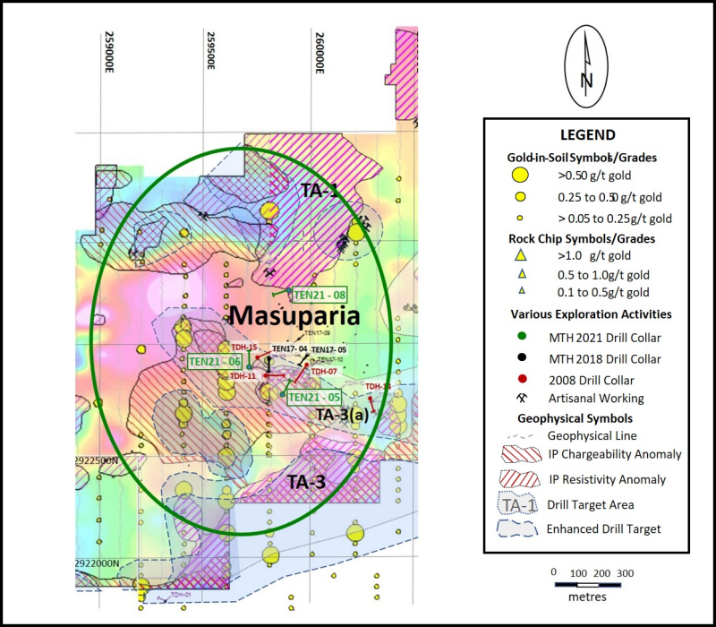
Click Image To View Full Size
Copyright (c) 2022 TheNewswire - All rights reserved.
Copyright (c) 2022 TheNewswire - All rights reserved., source


