(via TheNewswire)
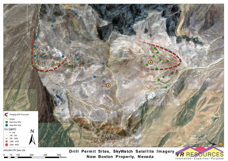
Figure 1. Satellite image showing selected drill sites for NOI permit applications for New Boston.
For strategic reasons, two separate NOI permit applications have been prepared to cover both the large IP chargeability anomaly at
Geophysical Targets for Drilling
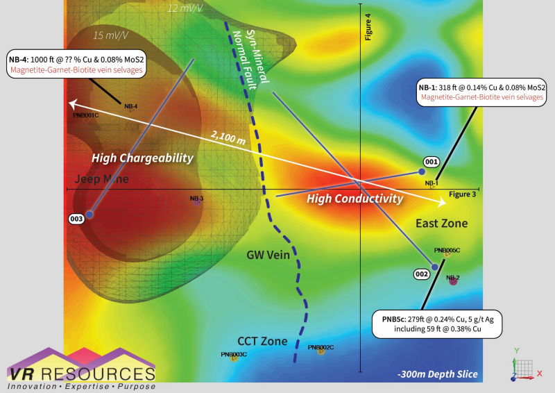
Figure 2.
Jeep Mine andEast Zone anomalies on conductivity plan map with superimposed IP isoshells.Figure 3. East-west profile through the 3D conductivity block model, showing convergence of
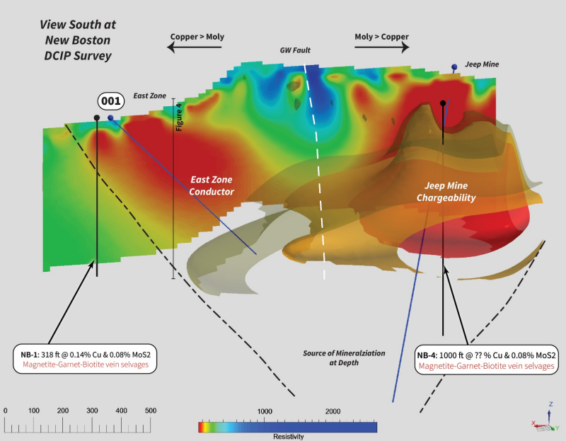
Jeep Mine andEast Zone anomalies at depth, below the central GW fault and mineralized gossan.Figure 4. North-south cross-section of conductivity block model, showing
East Zone conductor as the potential porphyry stock source to copper mineralization on surface atCCT Zone .
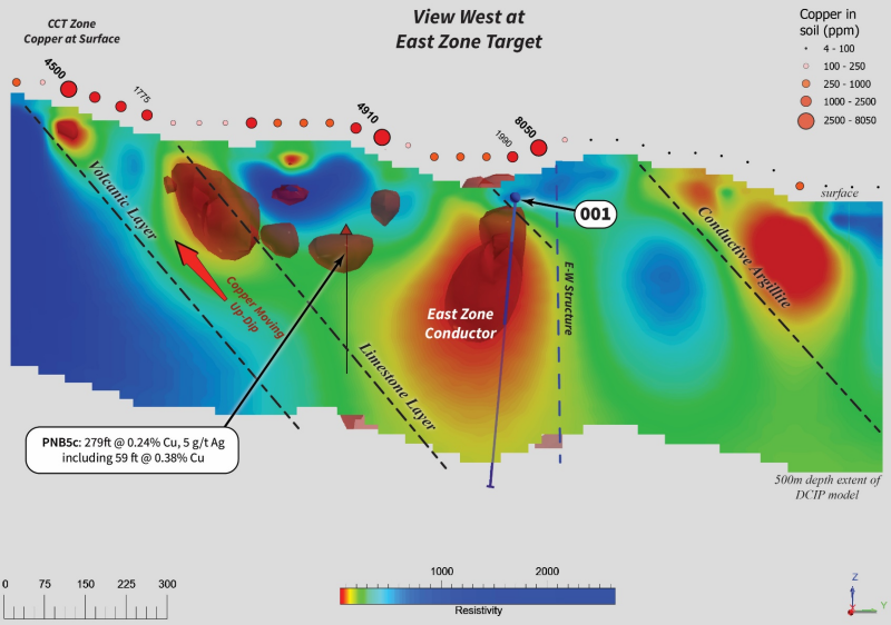
The East Zone Target for Copper
The ground DCIP conductor at
Copper at surface. The core of the conductor comes to surface into a patch of maroon-coloured soil amongst hematite skarn and intense quartz vein stockworks, with up to0.8% copper in soil
Copper Intersections. A 2010 drill hole located 300m to the south of the conductor, up-dip in limestone, intersected 279ft @ 0.24% Cu from 12ft depth, coincident with a small conductor;
Strike length. Starting from the maroon soil surface expression, the EZ conductor extends900 mto the northwest on plan map, and converges with the
Jeep Mine conductor at depth (Figure 3);Open to depth. The EZ conductor plunges from surface through the500 metredepth extent of the 3D voxel model; amplitude strengthens and volume increases with depth, and is open.
The new conductor at
1. There are bona fide polyphasestockwork veingeometries of quartz with copper sulfide, at surface;
2. There are bona fide daciteporphyry dykestogether with quartz monzonite stocks, at surface, and;
3. There are bona fide high temp.potassic alterationmineral assemblages with biotite and magnetite.
Site Visit & Field Video
VR completed a site visit to New Boston last week; a short field video is available on the Home Page of the Company’s website at www.vrr.ca. The purpose of the trip was to meet with potential drill contractors in person, in the field, to discuss the logistics for the planned first-pass drill program at
CEO Comment
From VR’s CEO, Dr.
Conoco branded New Boston as world class and perhaps one of the largest known moly systems in the world at the time - during the porphyry exploration boom in western
The US government has recently added copper to the top of its Critical Metal list for domestic, raw material supply for sustainable, downstream technologies and industries as the Green Economy emerges.
I encourage shareholders to review the figures herein and on our website in order to fully appreciate thesize,amplitudeandclarityof the conductivity anomaly at
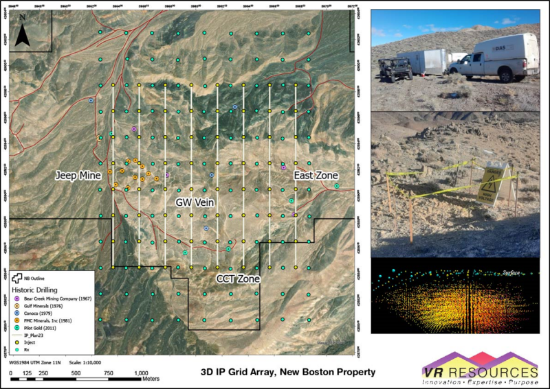
Description of
Figure 5. Satellite image showing the ground-based 3D IP geophysical survey completed in April by
An equant grid of 200 metre–spaced stations over a survey a 1.6 x 2.2 km block covers the 2,100m strike of sheeted veins exposed on surface in the main part of the skarn and porphyry system exposed on surface at New Boston.
The survey generated more than 80,000 data points for inversion modeling and resultant 3D models of chargeability and resistivity.
Technical Information
Summary technical and geological information for the Company’s various exploration properties including New Boston is available at the Company’s website atwww.vrr.ca.
Technical information for this news release has been prepared in accordance with the Canadian regulatory requirements set out in National Instrument 43-101.
About the New Boston Property
Location
New Boston is within the
New Boston is located in the
The property location facilitates cost-effective exploration, year-round. Access is from the nearby town of
Property Description
The New Boston property is large. It consists of 77 claims in one contiguous block approximately 3 x 5km in size and covering 583 hectares in total (1,441 acres). It covers the entire extent of the known copper-moly-silver porphyry-skarn mineral system exposed on surface between
The property is on federal land administered by the
The property is owned 100% by VR. There are no underlying annual lease payments; nor are there any joint venture or back-in interests. The vendor of the property retains a royalty.
About
VR is an established junior exploration company based in
ON BEHALF OF THE BOARD OFDIRECTORS:
“Michael H. Gunning”
____________________________
Dr.
President & CEO
For general information please use the following:
Website:www.vrr.ca
Email:info@vrr.ca
Phone: 778-731-9292
Forward Looking Statements
This news release contains statements that constitute "forward-looking statements". Such forward looking statements involve known and unknown risks, uncertainties and other factors that may cause the Company’s actual results, performance or achievements, or developments in the industry to differ materially from the anticipated results, performance or achievements expressed or implied by such forward-looking statements. Forward-looking statements are statements that are not historical facts and are generally, but not always, identified by the words "expects," "plans," "anticipates," "believes," "intends," "estimates," "projects," "potential" and similar expressions, or that events or conditions "will," "would," "may," "could" or "should" occur. Forward-looking statements in this document include statements concerningVR’sexpectations concerning theHecla-Kilmer property and all other statements that are not statements of historical fact.
Although the Company believes the forward-looking information contained in this news release is reasonable based on information available on the date hereof, by their nature forward-looking statements involve assumptions, known and unknown risks, uncertainties and other factors which may cause our actual results, performance or achievements, or other future events, to be materially different from any future results, performance or achievements expressed or implied by such forward-looking statements.
Examples of such assumptions, risks and uncertainties include, without limitation, assumptions, risks and uncertainties associated with general economic conditions; the Covid-19 pandemic; adverse industry events; future legislative and regulatory developments in the mining sector; the Company’s ability to access sufficient capital from internal and external sources, and/or inability to access sufficient capital on favorable terms; mining industry and markets in
The forward-looking information contained in this news release represents the expectations of the Company as of the date of this news release and, accordingly, is subject to change after such date. Readers should not place undue importance on forward-looking information and should not rely upon this information as of any other date. While the company may elect to, it does not undertake to update this information at any particular time except as required in accordance with applicable laws.
This news release may also contain statements and/or information with respect to mineral properties and/or deposits which are adjacent to and/or potentially similar to the Company’s mineral properties, but which the Company has no interest in nor rights to explore. Readers are cautioned that mineral deposits on similar properties are not necessarily indicative of mineral deposits on the Company’s properties.
Trading in the securities of the Company should be considered highly speculative. All of the Company’s public disclosure filings may be accessed viawww.sedarplus.caand readers are urged to review them.
Neither the
---
Click Image To View Full Size
Figure 1. Satellite image with drill site locations in the Notice of Intent (NOI) drill permit applications for the
Click Image To View Full Size
Figure 2. Plan map with IP isoshells overlain on a conductivity depth slice base map. The IP anomaly at
Click Image To View Full Size
Figure 3. View south at east-west profile slice through the 3D conductivity model shown on plan map in Figure 2. Copper-silver veins on surface along the GW fault and gossan trace (see Figure 2) emanate vertically upwards from the central part of this view where the
Click Image To View Full Size
Figure 4. North-south cross-section through the 3D conductivity model shown on plan map in Figure 2. Note soil copper geochemistry above the profile, with up to 0.8% Cu above
Click Image To View Full Size
Figure 5. Outline of ground-based 3D-array DCIP geophysical survey completed over New Boston by
Copyright (c) 2023 TheNewswire - All rights reserved.
Copyright (c) 2023 TheNewswire - All rights reserved., source
